Use of Remote Sensing to Assess Political Durability
The Use of Remote Sensing to Support the Assessment of Political Durability.
Author | Editor: Canna, S., Baker, T. & Yager, M. (NSI, Inc).
The Use of Remote Sensing to Support the Assessment of Political Durability Pilot Workshop was held jointly by the Strategic Multilayer Assessment (SMA) Office and the US Army Corps of Engineers (USACE) Engineer Research and Development Center (ERDC) from 7-8 December 2010 in Arlington, Virginia. The workshop is part of a proposed effort called Observable Manifestations of Hearts & Minds: Identifying Opportunities for Remotely Sensing Popular Perceptions Effort.
The goal of the proposed project is to develop regionally tailored, global remote sensing1 collection requirements and strategies in order to identify the sources of fragility and, potentially, early action when fragile states show vulnerability. The first step is to take a deep dive into the use of remote sensing technologies to assist social science assessments in the areas of governance, security, and development.
Environmental conditions manifest constraints and enablers on human activities, community resilience, and regional situations. At the same time, humans exert influence on the environment, which reflect changes in agriculture, development and, indirectly, population-based characteristics, behaviors, and trends. This conceptual bridge points to the potential that one can use remote sensing as proxies or compliments for political, social, military, economic, and other variables of concern to the evaluation of stability and resilience. Accordingly, measurable environmental change exhibited on the Earth surface may provide an important, though indirect, indication of state stability or potential conflict, acting in combination with other social-economic and institutional factors.
Over the past decade, several major research efforts link natural sciences through the study of land- use and land-cover change with the social sciences. However, many of the efforts result in models generally too complex for non-researchers. We urgently need to adapt and accelerate the convergence of social and physical data into a coherent implementation strategy, which, for example, the US Government can use today in the Counterinsurgency (COIN) environment and which can also extend globally to provide more robust indication of stability indices in areas of national concern. In a COIN environment, the potential role of remote sensing becomes very important due to the cost and risk associated with gathering information and making assessments using deployed forces.
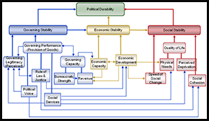
In Afghanistan, transition decisions by the International Security Assistance Force (ISAF) involve identification of “stable” governing and economic systems, as well as resilience of that (stable) condition. We define political durability as a function of governing, economic, and social stability. In this case, why do we think that “durability” rather than just stability has critical importance? A system that proves stable under a given set of conditions can nevertheless contain latent drivers of instability, which emerge once conditions become different. Transition from ISAF to local leadership in Afghanistan represents such a change in conditions.
For determining when a political system has stability and resiliency sufficient for self-sustainment in the face of internal and external shocks, we can use a conceptual framework called a Durability Model. For Afghanistan, the Durability Model aims to support ISAF transition decisions by providing decision makers with a theoretically rigorous, yet intuitively reasonable, framework for understanding the complex Afghan environment. Indicators lead to derived operationalized variables and to suggestions for data requirements and collection methods, (e.g., social services– water measured as an observable plus a survey item). The degree to which remotely-measured environmental indicators can support a durability framework remains unexplored.
The workshop had a two-fold objective:
- to provide a pilot forum to discover, explore, and develop the nexus between remotely- sensed environmental indicators and population-based metrics using the situation in Afghanistan as a use case; and
- to set the scope, terms, and charter for subsequent efforts across the DoD, inter-agency community, and the science academies to learn and discuss the potential of remotely- sensed physical/environmental data in a surrogacy or complimentary role for operational metrics in stability operations (tactical) and/or in a role as a long-term indicator of political durability (strategic).
On the first day, participants shared their expertise in remote sensing technologies, operational objectives and metrics, social and cultural data from the Pakistan and Afghanistan Rich Contextual Understanding (PAKAF RCU) Study, causes of state failure, and related agency initiatives and research. By the end of the first day, items of interest for further recommendation to ISAF were identified for development.
On the second day, participants broadened the discussion to explore the feature space of situations not particular to the Afghanistan case study. Participants examined similarities and dissimilarities between the case study and the wider global situation. In the afternoon, participants developed the concept and charter for a second workshop in early spring 2011 to take some of the salient generalities and specific recommendations from this effort to a broader dialogue.
Understanding the spectrum of remote sensing opportunities in the context of population-based frameworks constitutes the long-term goal. The effort also seeks to develop regionally tailored, global remote sensing collection requirements and strategies in order to identify the sources of fragility and early action when fragile states show vulnerability. Accordingly, the learning, outcome, and recommendations from this pilot event will lead to a more broad-based workshop early in 2011 and associated white paper.
Download Publication
Comments